Least Tern
Sternula antillarum
The Least Tern (Sternula antillarum) is a bird in the family Laridae. USGS maps its range in 35 of the lower 48 states, most widely in Louisiana, where it covers 74% of the state. Adults weigh about 1.6 oz (46 g).
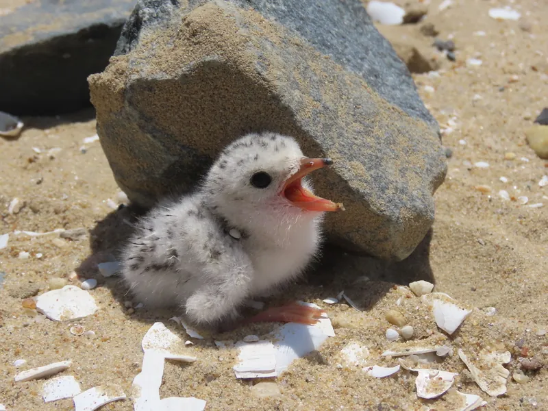
Across most of its mapped range it is a summer bird.
It eats mainly fish and other aquatic animals. AVONET classes it as a migrant.
The USGS habitat model maps it across 55 land-cover types. The USGS habitat model keeps it within 1,000 m of flowing water, open water or wet vegetation.
Open-licence records from the lower 48 (7,399 of them) peak in June and are fewest in November. A typical clutch is about 2. The longest recorded lifespan is 24.1 years.
Where the Least Tern lives
| State | Share of state | Counties | Open records | Peak month |
|---|---|---|---|---|
| Louisiana migration | 74% | 53 of 64 | 236 | June |
| Maryland summer | 46% | 17 of 24 | 314 | June |
| Rhode Island summer | 44% | 5 of 5 | 41 | June |
| Florida summer | 42% | 46 of 67 | 966 | May |
| Delaware summer | 41% | 3 of 3 | 48 | June |
| New Jersey summer | 33% | 12 of 21 | 393 | June |
| Massachusetts summer | 24% | 8 of 14 | 588 | June |
| New Mexico migration | 22% | 15 of 33 | 9 | |
| Connecticut summer | 21% | 5 of 9 | 97 | June |
| Nebraska summer | 20% | 46 of 93 | 2,738 | July |
| Colorado migration | 19% | 28 of 64 | 12 | |
| Oklahoma summer | 16% | 38 of 77 | 1,490 | June |
| Mississippi summer | 16% | 20 of 82 | 817 | June |
| Texas migration | 13% | 70 of 254 | 963 | May |
| South Carolina summer | 13% | 8 of 46 | 273 | May |
| North Carolina summer | 11% | 19 of 100 | 156 | May |
| Arkansas summer | 11% | 25 of 75 | 569 | |
| Virginia summer | 10% | 26 of 133 | 313 | June |
| Missouri migration | 10% | 32 of 115 | 918 | May |
| Kansas summer | 9% | 23 of 105 | 1,038 | June |
| South Dakota summer | 8% | 17 of 66 | 2,243 | |
| California summer | 6% | 12 of 58 | 68,252 | June |
| North Dakota migration | 6% | 11 of 53 | 920 | |
| Georgia summer | 5% | 9 of 159 | 129 | June |
| Kentucky summer | 4% | 9 of 120 | 664 | |
| Arizona migration | 4% | 2 of 15 | 4 | |
| New York summer | 4% | 8 of 62 | 173 | July |
| Tennessee summer | 4% | 6 of 95 | 1,333 | |
| New Hampshire summer | 3% | 2 of 10 | 8 | |
| Iowa summer | 2% | 6 of 99 | 31 | |
| Illinois migration | 2% | 10 of 102 | 11 | |
| Alabama summer | 2% | 2 of 67 | 57 | June |
| Maine summer | 2% | 2 of 16 | 37 | June |
| Nevada migration | 2% | 1 of 17 | 1 | |
| Montana summer | under 1% | 2 of 56 |
Share of state is the part of each state inside the range map. Counties counts those with at least a tenth of their area in range. A state link opens that state's full list.
When it is recorded
Lists it appears on
Sources
- AVONET: morphological ecological and geographical data for all birds. CC BY 4.0. Read 2026-11-15.
- Amniote life-history database. CC0. Read 2026-11-15.
- GBIF Backbone Taxonomy. CC BY 4.0. Read 2026-11-15.
- GBIF occurrence records under CC0 and CC BY 4.0. CC0 and CC BY 4.0 per record. Read 2026-11-15.
- Integrated Taxonomic Information System. CC0. Read 2026-11-15.
- US Census Bureau cartographic boundary files 2023. Public domain (US Census Bureau). Read 2026-11-15.
- USGS GAP 12-digit hydrologic unit range units. Public domain (USGS). Read 2026-11-15.
- USGS Gap Analysis Project Species Habitat Maps CONUS_2001 (model parameters). Public domain (USGS). Read 2026-11-15.
- USGS Gap Analysis Project Species Range Maps CONUS_2001. Public domain (USGS). Read 2026-11-15.
- iNaturalist photographs under CC0 and CC BY. CC0 and CC BY per photograph. Read 2026-11-15.
How each figure is derived is set out on the methods page.